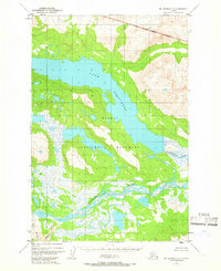
1951 Map of Mount Katmai C-4
USGS Topo · Published 1965About this map
Lake Grosvenor dominates the upper-central portion of this landscape, its waters stretching across an unsurveyed wilderness during the early 1950s. The region is largely defined by the sprawling Katmai National Monument, showing the approximate boundaries as they existed shortly after the territory was established. Below the lake, a complex drainage system features the braided channels of the Savonoski River and the inflow of Hardscrabble Creek. This 1951 survey, based on photogrammetric methods from aerial photographs, illustrates the vast, unpopulated terrain of the Alaska Peninsula. Evidence of dynamic glacial and volcanic hydrology is visible in the shifting paths of the Ukak River and Ikagluik Creek near the southwestern corner. The map reflects a period when many land lines remained unsurveyed, relying on predetermined locations from the Bureau of Land Management.
Find a feature on this map
8 named features on this map. Tap any name to fly to it.
Don’t see what you’re looking for? This feature index may not catch every label — zoom into the map to look around manually.
Map Details
Editions of this 1951 Mount Katmai C-4 Map
2 editions found
Other maps of this area

1948 · Mt Katmai
USGS Topo · 1:250,000

1951 · Mt Katmai
USGS Topo · 1:250,000

1951 · Mount Katmai C-3
USGS Topo · 1:63,360

1951 · Mount Katmai B-4
USGS Topo · 1:63,360

1951 · Mount Katmai D-5
USGS Topo · 1:63,360

1951 · Mount Katmai C-5
USGS Topo · 1:63,360

1951 · Mount Katmai C-4
USGS Topo · 1:63,360

1951 · Mount Katmai D-4
USGS Topo · 1:63,360

1951 · Mount Katmai D-3
USGS Topo · 1:63,360

1951 · Mount Katmai B-3
USGS Topo · 1:63,360