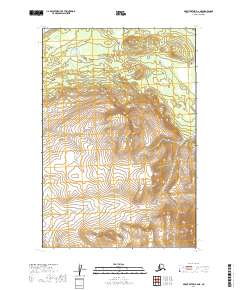
2019 Map of Mount Katmai B-6 NE
USGS Topo · Published 2019About this map
Katmai National Park encompasses this entire stretch of the Alaska Peninsula, where the landscape is defined by the significant elevation and steep contours of the Aleutian Range. At the heart of this terrain stands Mt Kelez, a prominent peak that serves as a focal point for the surrounding topography. The map illustrates the sophisticated surveying of the Public Land Survey System, dividing the wilderness into townships and ranges such as t20s r39w and t21s r40w. This 2019 data captures a high-altitude environment shaped by dramatic vertical relief, providing an essential record of the protected lands within Lake and Peninsula Borough before the shifting of modern glacial or volcanic activity impacts these remote coordinates.
Find a feature on this map
8 named features on this map. Tap any name to fly to it.
Don’t see what you’re looking for? This feature index may not catch every label — zoom into the map to look around manually.
Map Details
Editions of this 2019 Mount Katmai B-6 NE Map
This is the sole edition of this map. No revisions or reprints were ever made.
Other maps of this area

1948 · Mt Katmai
USGS Topo · 1:250,000

1951 · Mt Katmai
USGS Topo · 1:250,000

1951 · Mount Katmai C-6
USGS Topo · 1:63,360

1951 · Mount Katmai B-6
USGS Topo · 1:63,360

1951 · Mount Katmai C-5
USGS Topo · 1:63,360

1951 · Mount Katmai B-5
USGS Topo · 1:63,360
1953 · Mt. Katmai B-6
USGS Topo · 1:63,360
1953 · Mount Katmai B-5
USGS Topo · 1:63,360
1953 · Mount Katmai C-5
USGS Topo · 1:63,360

1964 · Mt. Katmai
USGS Topo · 1:250,000