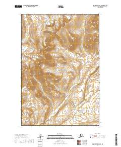
2019 Map of Mount Katmai B-6 SE
USGS Topo · Published 2019About this map
Katmai National Park encompasses the entirety of this 2019 topographic survey in the Lake and Peninsula borough of Alaska. The landscape is dominated by steep, high-elevation terrain, with numerous peaks and ridges defined by tight contour lines. The most significant drainage feature is Contact Creek, which flows through the southeastern portion of the quadrangle. The map is primarily an exploration of wilderness geography, showing the complex watershed patterns and elevation shifts typical of the Aleutian Range. There are no signs of human development, roads, or named settlements, reflecting the preserved and primitive nature of this protected area. Public land survey boundaries, including t22s r39w and t21s r40w, provide a structural grid over the mountainous interior, aiding in the spatial orientation of this roadless region.
Find a feature on this map
6 named features on this map. Tap any name to fly to it.
Don’t see what you’re looking for? This feature index may not catch every label — zoom into the map to look around manually.
Map Details
Editions of this 2019 Mount Katmai B-6 SE Map
This is the sole edition of this map. No revisions or reprints were ever made.
Other maps of this area

1948 · Mt Katmai
USGS Topo · 1:250,000

1951 · Mt Katmai
USGS Topo · 1:250,000

1951 · Mount Katmai A-6
USGS Topo · 1:63,360

1951 · Mount Katmai B-6
USGS Topo · 1:63,360

1951 · Mount Katmai B-5
USGS Topo · 1:63,360

1951 · Mount Katmai A-5
USGS Topo · 1:63,360
1953 · Mt. Katmai B-6
USGS Topo · 1:63,360
1953 · Mount Katmai B-5
USGS Topo · 1:63,360

1964 · Mt. Katmai
USGS Topo · 1:250,000
2019 · Mount Katmai B-6 NE
USGS Topo · 1:25,000