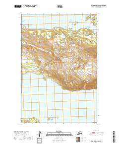
2019 Map of Mount Katmai C-5 SW
USGS Topo · Published 2019About this map
Katmai National Park encompasses the rugged landscape of this 2019 survey, where the peaks of Mt La Gorce rise above the massive freshwater expanses of Naknek Lake. The map reveals a wild, protected interior devoid of permanent settlements or roads, focusing instead on the high-altitude topography and the complex shoreline of the lake's northern and southern arms. The cartography emphasizes the natural divide between the mountainous terrain of the Aleutian Range and the water bodies that dominate the lowlands, providing a clear view of the wilderness as it appeared in the early 21st century.
Find a feature on this map
7 named features on this map. Tap any name to fly to it.
Don’t see what you’re looking for? This feature index may not catch every label — zoom into the map to look around manually.
Map Details
Editions of this 2019 Mount Katmai C-5 SW Map
This is the sole edition of this map. No revisions or reprints were ever made.
Other maps of this area

1948 · Mt Katmai
USGS Topo · 1:250,000

1951 · Mt Katmai
USGS Topo · 1:250,000

1951 · Mount Katmai C-6
USGS Topo · 1:63,360

1951 · Mount Katmai B-6
USGS Topo · 1:63,360

1951 · Mount Katmai C-5
USGS Topo · 1:63,360

1951 · Mount Katmai B-5
USGS Topo · 1:63,360
1953 · Mt. Katmai B-6
USGS Topo · 1:63,360
1953 · Mount Katmai B-5
USGS Topo · 1:63,360
1953 · Mount Katmai C-5
USGS Topo · 1:63,360

1964 · Mt. Katmai
USGS Topo · 1:250,000