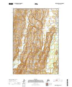
2019 Map of Mount Katmai D-1 NW
USGS Topo · Published 2019About this map
Katmai National Park encompasses the majority of this landscape, where the drainage systems of the Alaska Peninsula shape the wild, unpopulated terrain. The Kamishak River flows through the eastern portion of the quadrangle, joined in the south by the South Fork Kamishak River. To the west, the topography is defined by the winding course of Strike Creek. This 2019 survey, based on data from the U.S. Geological Survey and the Bureau of Land Management, provides a precise look at the township and range lines across the Kenai Peninsula Borough. The map detail highlights the steep elevation changes and natural watercourses that dictate travel and land use within these protected federal boundaries.
Find a feature on this map
8 named features on this map. Tap any name to fly to it.
Don’t see what you’re looking for? This feature index may not catch every label — zoom into the map to look around manually.
Map Details
Editions of this 2019 Mount Katmai D-1 NW Map
This is the sole edition of this map. No revisions or reprints were ever made.
Other maps of this area

1948 · Mt Katmai
USGS Topo · 1:250,000

1951 · Mt Katmai
USGS Topo · 1:250,000

1951 · Iliamna A-4
USGS Topo · 1:63,360

1951 · Mount Katmai D-1
USGS Topo · 1:63,360

1951 · Mount Katmai D-2
USGS Topo · 1:63,360

1952 · Iliamna
USGS Topo · 1:250,000

1952 · Iliamna A-4
USGS Topo · 1:63,360
1953 · Mount Katmai D-1
USGS Topo · 1:63,360

1957 · Iliamna
USGS Topo · 1:250,000

1964 · Mt. Katmai
USGS Topo · 1:250,000