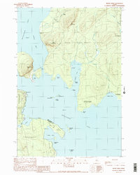
1989 Map of Mount Kineo
USGS Topo · Published 1989About this map
Mount Kineo dominates the western shoreline of Moosehead Lake, providing a dramatic topographical anchor to this northern Maine wilderness. This 1989 survey details the intricate shoreline and surrounding land grants, including Days Academy Grant and the Sand Bar Tract. The landscape is characterized by its numerous coves, such as Harris Cove and Kineo Cove, and a scattering of named islands like East Moody Island and Masterman Island. Evidence of human activity is found at Deer Head Farm and the boat ramp facilities near Cowan Cove.
Find a feature on this map
38 named features on this map. Tap any name to fly to it.
Don’t see what you’re looking for? This feature index may not catch every label — zoom into the map to look around manually.
Map Details
Editions of this 1989 Mount Kineo Map
2 editions found
Other maps of this area

1920 · Moosehead Lake
USGS Topo · 1:62,500

1921 · Brassua Lake
USGS Topo · 1:62,500

1922 · Moosehead Lake
USGS Topo · 1:62,500

1923 · Brassua Lake
USGS Topo · 1:62,500

1930 · Moosehead Lake
USGS Topo · 1:62,500

1944 · Brassua Lake
USGS Topo · 1:62,500

1944 · Moosehead Lake
USGS Topo · 1:62,500

1954 · Seboomook Lake
USGS Topo · 1:62,500

1954 · North East Carry
USGS Topo · 1:62,500

1954 · Millinocket
USGS Topo · 1:250,000
Featured Places
- Misery Gore, ME
- Days Academy Grant Township, ME
- Spencer Bay Township, ME
- Sandbar Tract Township, ME
- Kineo Township, ME