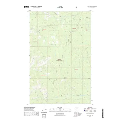
2020 Map of Mount Leona
USGS Topo · Published 2020About this map
Colville National Forest dominates this section of the Kettle River Range in Ferry County, where the topography is defined by significant elevations and a dense network of mountain drainages. High points like Mt Leona and Profanity Peak anchor the central and southern portions of the map, while Tonasket Mtn and Sentinel Butte overlook the surrounding valleys. The passage of the Pacific NW National Scenic Trail indicates the modern recreational use of these ridges, winding past landmarks like Ryan Hill and the remote Ryan Cabin. The hydrology is complex, with headwaters for various systems including N Fork Boulder Cr and S Fork Saint Peter Cr flowing from the high slopes. Access remains limited to forest routes like Boulder Creek Rd and Albion Hill, preserving the wilderness character of the Taylor Ridge area.
Find a feature on this map
38 named features on this map. Tap any name to fly to it.
Don’t see what you’re looking for? This feature index may not catch every label — zoom into the map to look around manually.
Map Details
Editions of this 2020 Mount Leona Map
This is the sole edition of this map. No revisions or reprints were ever made.
Other maps of this area

1904 · Republic
USGS Topo · 1:125,000

1936 · Marcus
USGS Topo · 1:96,000

1942 · Marcus
USGS Topo · 1:125,000

1948 · Curlew
USGS Topo · 1:62,500

1948 · Republic
USGS Topo · 1:62,500

1948 · Sherman Peak
USGS Topo · 1:62,500

1948 · Togo Mountain
USGS Topo · 1:62,500

1951 · Togo Mountain
USGS Topo · 1:62,500

1951 · Sherman Peak
USGS Topo · 1:62,500

1951 · Curlew
USGS Topo · 1:62,500