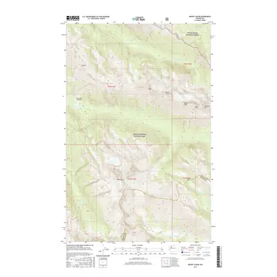
2017 Map of Mount Logan
USGS Topo · Published 2017About this map
Mount Logan dominates the central landscape of this high-altitude region along the border of Skagit and Chelan counties. This 2017 survey details the complex network of ridges and watercourses within the North Cascades National Park and Mount Baker National Forest. A series of prominent summits, including Cosho Peak, Kimtah Peak, and Katsuk Peak, form the high ground of Ragged Ridge and Mesahchie Peak. The drainage patterns are clearly defined by Fisher Creek, Panther Creek, and the North Fork Bridge Creek. Notable landmarks like Fisher Pass and the Rock Cabin Avalanche area provide specific reference points for navigating this glaciated terrain. The map is a precise record of the natural boundaries and elevations of the Cascades as they appeared in the early twenty-first century.
Find a feature on this map
30 named features on this map. Tap any name to fly to it.
Don’t see what you’re looking for? This feature index may not catch every label — zoom into the map to look around manually.
Map Details
Editions of this 2017 Mount Logan Map
This is the sole edition of this map. No revisions or reprints were ever made.
Other maps of this area

1899 · Glacier Peak
USGS Topo · 1:125,000

1901 · Glacier Peak
USGS Topo · 1:125,000

1902 · Stehekin
USGS Topo · 1:125,000

1904 · Stehekin
USGS Topo · 1:125,000

1920 · Slate Pass
USGS Topo · 1:125,000

1955 · Concrete
USGS Topo · 1:250,000

1958 · Concrete
USGS Topo · 1:250,000

1962 · Concrete
USGS Topo · 1:250,000

1963 · Mc Gregor Mtn
USGS Topo · 1:24,000

1963 · Azurite Peak
USGS Topo · 1:24,000