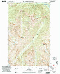
2004 Map of Mount Lyall
USGS Topo · Published 2008About this map
Pacific Crest National Scenic Trail traverses the high ridges of the North Cascades in this 2004 revision, marking a critical corridor through some of Washington's most protected alpine environments. The map documents the convergence of several major land designations, including North Cascades National Park, the Lake Chelan National Recreation Area, and the Glacier Peak Wilderness. Notable water features like the Stehekin River and the northern reach of Lake Chelan flow through the deep glacially-carved valleys, while high-altitude landmarks such as Mount Lyall, Tupshin Peak, and White Goat Mountain dominate the skyline. Hikers and researchers can trace the routes through Agnes Gorge or locate established campsites near Company Creek and Hiltgard Creek, illustrating the recreational infrastructure managed by the Forest Service at the start of the 21st century.
Find a feature on this map
33 named features on this map. Tap any name to fly to it.
Don’t see what you’re looking for? This feature index may not catch every label — zoom into the map to look around manually.
Map Details
Editions of this 2004 Mount Lyall Map
This is the sole edition of this map. No revisions or reprints were ever made.
Other maps of this area

1902 · Stehekin
USGS Topo · 1:125,000

1904 · Stehekin
USGS Topo · 1:125,000

1944 · Holden
USGS Topo · 1:62,500

1944 · Lucerne
USGS Topo · 1:62,500

1949 · Lucerne
USGS Topo · 1:62,500

1949 · Holden
USGS Topo · 1:62,500

1955 · Concrete
USGS Topo · 1:250,000

1958 · Concrete
USGS Topo · 1:250,000

1962 · Concrete
USGS Topo · 1:250,000

1963 · Mc Gregor Mtn
USGS Topo · 1:24,000