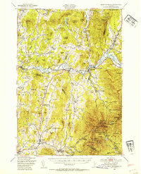
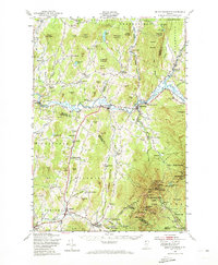
1948 Map of Mount Mansfield
USGS Topo · Published 1954About this map
Mt Mansfield State Forest and its namesake peak dominate the eastern landscape, where early ski infrastructure like the State Ski Dormitory, Taft Lodge, and the Mt Mansfield Hotel are already established near The Long Trail. The Lamoille River valley serves as a primary transit corridor, hosting the St Johnsbury and Lamoille Co RR and the village of Cambridge Junction. Settlement patterns show a high density of rural schoolhouses and distinct ethnic enclaves such as the Irish Settlement and English Settlement in the township of Underhill. This topography illustrates a transition from the rugged slopes of the Green Mountains to the agricultural valleys where numerous family-named landmarks like Sanderson Corner and Smiley Sch reflect a deeply rooted local community. The presence of Morse Mill and the Fairfax Falls hydroelectric facilities indicate how the region’s water power was being utilized at mid-century.
Find a feature on this map
143 named features on this map. Tap any name to fly to it.
Don’t see what you’re looking for? This feature index may not catch every label — zoom into the map to look around manually.
Map Details
Editions of this 1948 Mount Mansfield Map
5 editions found
Other maps of this area

1906 · Burlington
USGS Topo · 1:62,500

1913 · Milton
USGS Topo · 1:48,000

1914 · St. Albans
USGS Topo · 1:48,000

1915 · Milton
USGS Topo · 1:62,500

1916 · St. Albans
USGS Topo · 1:62,500

1919 · Burlington
USGS Topo · 1:62,500

1919 · Montgomery
USGS Topo · 1:62,500

1919 · Montpelier
USGS Topo · 1:62,500

1920 · Franklin Pond
USGS Topo · 1:62,500

1920 · Montgomery
USGS Topo · 1:62,500