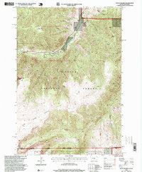
1996 Map of Mount Maurice
USGS Topo · Published 1999About this map
The high-altitude Divide between the Custer National Forest and Shoshone National Forest dominates this mid-1990s survey of the Montana-Wyoming border. This landscape is defined by the massive Line Creek Plateau, which transitions into sharp peaks such as Mount Maurice and the Westminster Spires. The presence of the Rattine road and Roadside Park along Rock Creek indicates the development of recreation and access into the backcountry of Carbon County, Montana. From the high vantage point of Sheridan Point, the map traces the complex drainage system of the Beartooth foothills, where Cyclone Creek and Seeley Creek have carved deep gulches into the mountain flanks. Evidence of earlier human activity appears at Sheridan and the Piney Dell area, marking the boundary between the forested slopes and the rugged plateaus.
Find a feature on this map
24 named features on this map. Tap any name to fly to it.
Don’t see what you’re looking for? This feature index may not catch every label — zoom into the map to look around manually.
Map Details
Editions of this 1996 Mount Maurice Map
This is the sole edition of this map. No revisions or reprints were ever made.
Other maps of this area

1944 · Red Lodge
USGS Topo · 1:62,500

1950 · Clark
USGS Topo · 1:62,500

1950 · Deep Lake
USGS Topo · 1:62,500

1954 · Billings
USGS Topo · 1:250,000

1955 · Cody
USGS Topo · 1:250,000

1956 · Mount Maurice
USGS Topo · 1:62,500

1957 · Billings
USGS Topo · 1:250,000

1958 · Billings
USGS Topo · 1:250,000

1958 · Cody
USGS Topo · 1:250,000

1962 · Cody
USGS Topo · 1:250,000