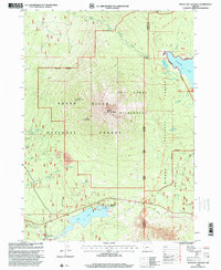
1998 Map of Mount Mc Loughlin
USGS Topo · Published 2000About this map
Mount Mc Loughlin stands as the central landmark of this late-twentieth-century landscape, surrounded by the deep woods of the Rogue River National Forest, Sky Lakes Wilderness, and Winema National Forest. The map documents a high-altitude recreation and water management system at the Jackson and Klamath County line. Notable water bodies including Fish Lake, with its Fish Lake Resort and Boat Ramp, and the expansive Fourmile Lake dominate the lower and eastern sections. A network of primitive infrastructure is visible, from the Gaging Station and Spillway 4642 to the Cascade Canal Trail. This survey illustrates the era's focus on conservation and trail access, featuring the Pacific Crest National Scenic Trail as it winds past Summit Lake and Squaw Lake toward the northern boundary at Camp 76.
Find a feature on this map
54 named features on this map. Tap any name to fly to it.
Don’t see what you’re looking for? This feature index may not catch every label — zoom into the map to look around manually.
Map Details
Editions of this 1998 Mount Mc Loughlin Map
This is the sole edition of this map. No revisions or reprints were ever made.
Other maps of this area

1891 · Ashland
USGS Topo · 1:250,000

1893 · Ashland
USGS Topo · 1:250,000

1897 · Ashland
USGS Topo · 1:250,000

1955 · Lake O' Woods
USGS Topo · 1:62,500

1955 · Rustler Peak
USGS Topo · 1:62,500

1955 · Mt. Mc Loughlin
USGS Topo · 1:62,500

1955 · Pelican Butte
USGS Topo · 1:62,500

1955 · Medford
USGS Topo · 1:250,000

1957 · Medford
USGS Topo · 1:250,000

1958 · Medford
USGS Topo · 1:250,000