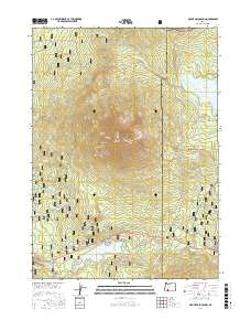
2017 Map of Mount McLoughlin
USGS Topo · Published 2017About this map
Mount McLoughlin dominates this high-altitude landscape where the Rogue River National Forest meets the Winema National Forest. The map documents a complex network of hydrological and recreational features along the Cascade crest, including the prominent Fish Lake and Fourmile Lake. Water management is a visible priority, evidenced by the Cascade Canal and the Lower Canal traversing the eastern slopes near High Lakes Pass. The Pacific Crest National Scenic Trail winds through the volcanic terrain, passing Summit Lake and Mirror Pond. Beneath the peaks, named clearings like Rye Flat and points of interest such as Doe Point suggest a landscape used for both forestry and alpine navigation. The presence of specialized pathways like the High Lakes Bike Trail and various ski routes underscores the area's development as a contemporary recreation hub within the national forests.
Find a feature on this map
62 named features on this map. Tap any name to fly to it.
Don’t see what you’re looking for? This feature index may not catch every label — zoom into the map to look around manually.
Map Details
Editions of this 2017 Mount McLoughlin Map
This is the sole edition of this map. No revisions or reprints were ever made.
Other maps of this area

1891 · Ashland
USGS Topo · 1:250,000

1893 · Ashland
USGS Topo · 1:250,000

1897 · Ashland
USGS Topo · 1:250,000

1955 · Lake O' Woods
USGS Topo · 1:62,500

1955 · Rustler Peak
USGS Topo · 1:62,500

1955 · Mt. Mc Loughlin
USGS Topo · 1:62,500

1955 · Pelican Butte
USGS Topo · 1:62,500

1955 · Medford
USGS Topo · 1:250,000

1957 · Medford
USGS Topo · 1:250,000

1958 · Medford
USGS Topo · 1:250,000