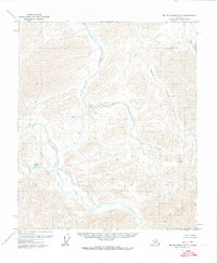
1971 Map of Mount Michelson A-5
USGS Topo · Published 1973About this map
Echooka River and Juniper Creek carve through this remote stretch of the North Slope, revealing a landscape defined by braided river systems and glacial topography. This 1971 field-annotated survey, based on aerial photography from the previous year, captures the area's drainage patterns and elevation contours in precise detail. Notable landmarks include the isolated Wahoo Lake in the southwest and the headwaters of the Kavik River to the east. The map provides a critical look at the drainage basin where Pogopuk Creek joins the larger waterways, documenting an era before significant infrastructure reached these northern latitudes.
Find a feature on this map
6 named features on this map. Tap any name to fly to it.
Don’t see what you’re looking for? This feature index may not catch every label — zoom into the map to look around manually.
Map Details
Editions of this 1971 Mount Michelson A-5 Map
This is the sole edition of this map. No revisions or reprints were ever made.
Other maps of this area

1951 · Sagavanirktok D-5
USGS Topo · 1:250,000

1951 · Brooks
USGS Topo · 1:250,000

1951 · Arctic
USGS Topo · 1:250,000

1951 · Mt. Michelson
USGS Topo · 1:250,000

1956 · Arctic
USGS Topo · 1:250,000

1956 · Mt. Michelson
USGS Topo · 1:250,000

1956 · Philip Smith Mountains
USGS Topo · 1:250,000

1956 · Sagavanirktok
USGS Topo · 1:250,000

1958 · Sagavanirktok
USGS Topo · 1:250,000

1964 · Philip Smith Mountains
USGS Topo · 1:250,000