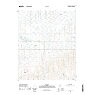
2018 Map of Mount Michelson C-2 NW
USGS Topo · Published 2018About this map
The Sadlerochit Mountains dominate the southern portion of this landscape, rising above a network of drainages that define the local topography. The Nularvik River carves a central path through the terrain, joined by tributaries such as W Nularvik Cr and E Nularvik Cr. This northern coastal slope environment is characterized by extensive wetlands and seasonal watercourses, including the eastern reaches of Marsh Cr and the specialized drainage of W Fork Marsh Cr. To the southeast, Camp 263 Cr flows from the mountain foothills, illustrating the complex hydrography of the North Slope. The area is largely defined by the Public Land Survey System boundaries of Townships 3 to 5 North, Ranges 28 to 29 East, representing a vast, undeveloped stretch of the Arctic wilderness prior to any modern infrastructure.
Find a feature on this map
13 named features on this map. Tap any name to fly to it.
Don’t see what you’re looking for? This feature index may not catch every label — zoom into the map to look around manually.
Map Details
Editions of this 2018 Mount Michelson C-2 NW Map
This is the sole edition of this map. No revisions or reprints were ever made.
Other maps of this area

1951 · Mt. Michelson
USGS Topo · 1:250,000

1955 · Mount Michelson C-3
USGS Topo · 1:63,360

1955 · Mount Michelson D-3
USGS Topo · 1:63,360

1955 · Mount Michelson C-2
USGS Topo · 1:63,360

1955 · Mount Michelson D-2
USGS Topo · 1:63,360

1956 · Mt. Michelson
USGS Topo · 1:250,000

1975 · Mount Michelson C-3
USGS Topo · 1:63,360
2018 · Mount Michelson C-3 SE
USGS Topo · 1:25,000
2018 · Mount Michelson C-2 SW
USGS Topo · 1:25,000
2018 · Mount Michelson D-2 SW
USGS Topo · 1:25,000