
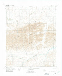
1955 Map of Mount Michelson C-2
USGS Topo · Published 1964About this map
The Sadlerochit Mountains dominate this 1955 topographic study of Alaska's North Slope, a landscape later designated as part of the Arctic National Wildlife Range. The terrain is defined by dramatic elevation changes, with Mount Weller rising above the northern coastal plain and Sunset Pass providing a natural break in the mountain chain. Highlighting the early scientific exploration of the Brooks Range foothills, Camp 263 is noted near the center of the sheet, likely representing a site from the original photogrammetric mapping by the Army Map Service. The complex hydrology of the region is traced through the Sadlerochit River and its numerous tributaries, including Marsh Creek, Itkilyariak Creek, and the Kekiktuk River. This document preserves the primitive geography of the Arctic before the infrastructure shifts of the late 20th century, focusing on natural landmarks like Ledge and Black Dog Creek.
Find a feature on this map
16 named features on this map. Tap any name to fly to it.
Don’t see what you’re looking for? This feature index may not catch every label — zoom into the map to look around manually.
Map Details
Editions of this 1955 Mount Michelson C-2 Map
2 editions found
Other maps of this area

1951 · Mt. Michelson
USGS Topo · 1:250,000

1955 · Mount Michelson B-1
USGS Topo · 1:63,360

1955 · Mount Michelson C-1
USGS Topo · 1:63,360

1955 · Mount Michelson C-3
USGS Topo · 1:63,360

1955 · Mount Michelson D-3
USGS Topo · 1:63,360

1955 · Mount Michelson D-2
USGS Topo · 1:63,360

1955 · Mount Michelson D-1
USGS Topo · 1:63,360

1956 · Mt. Michelson
USGS Topo · 1:250,000

1956 · Mount Michelson B-2
USGS Topo · 1:63,360

1956 · Mount Michelson B-3
USGS Topo · 1:63,360