
1956 Map of Mount Michelson B-2
USGS Topo · Published 1966About this map
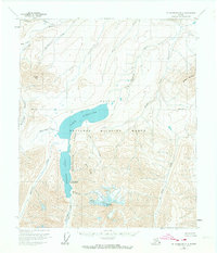
Arctic National Wildlife Range dominates this mid-century topographic study, showcasing a high-latitude wilderness defined by massive glaciers and alpine lakes. Centered on the Neruokpuk Lakes system, the map documents the proximity of Lake Schrader and Lake Peters, which are fed by glacial runoff from the south. The dramatic elevation changes are anchored by Mount Chamberlin, where both the Peters Glacier and Chamberlin Glacier are clearly delineated.
Find a feature on this map
23 named features on this map. Tap any name to fly to it.
Don’t see what you’re looking for? This feature index may not catch every label — zoom into the map to look around manually.
Map Details
Editions of this 1956 Mount Michelson B-2 Map
2 editions found
Other maps of this area

1951 · Mt. Michelson
USGS Topo · 1:250,000

1955 · Mount Michelson B-1
USGS Topo · 1:63,360

1955 · Mount Michelson C-1
USGS Topo · 1:63,360

1955 · Mount Michelson C-3
USGS Topo · 1:63,360

1955 · Mount Michelson C-2
USGS Topo · 1:63,360

1956 · Mt. Michelson
USGS Topo · 1:250,000

1956 · Mount Michelson B-3
USGS Topo · 1:63,360

1975 · Mount Michelson C-3
USGS Topo · 1:63,360

1983 · Mount Michelson A-3
USGS Topo · 1:63,360
1983 · Mount Michelson A-1
USGS Topo · 1:63,360