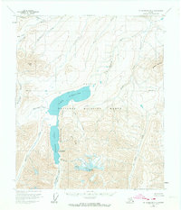
1956 Map of Mount Michelson B-2
USGS Topo · Published 1974About this map
Lake Schrader and Lake Peters form the heart of this high-latitude study of the eastern North Slope, part of the extensive Arctic National Wildlife Range. Collectively known as the Neruokpuk Lakes, these glacial water bodies are fed by the meltwaters of Chamberlin Glacier and Peters Glacier, which drape the slopes of Mount Chamberlin. The presence of the G William Holmes Research Station on the shore of Lake Peters highlights the importance of this region for environmental and geological observation during the mid-20th century.
Find a feature on this map
25 named features on this map. Tap any name to fly to it.
Don’t see what you’re looking for? This feature index may not catch every label — zoom into the map to look around manually.
Map Details
Editions of this 1956 Mount Michelson B-2 Map
2 editions found
Other maps of this area

1951 · Mt. Michelson
USGS Topo · 1:250,000

1955 · Mount Michelson B-1
USGS Topo · 1:63,360

1955 · Mount Michelson C-1
USGS Topo · 1:63,360

1955 · Mount Michelson C-3
USGS Topo · 1:63,360

1955 · Mount Michelson C-2
USGS Topo · 1:63,360

1956 · Mt. Michelson
USGS Topo · 1:250,000

1956 · Mount Michelson B-2
USGS Topo · 1:63,360

1956 · Mount Michelson B-3
USGS Topo · 1:63,360

1975 · Mount Michelson C-3
USGS Topo · 1:63,360

1983 · Mount Michelson A-3
USGS Topo · 1:63,360