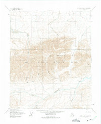
1955 Map of Mount Michelson C-2
USGS Topo · Published 1975About this map
The Sadlerochit Mountains dominate this 1955 topographic study of Alaska’s North Slope, a landscape then recently designated as part of the Arctic National Wildlife Range. Central to the quadrangle is Mount Weller, standing amidst a complex network of waterways that flow toward the Arctic coast. The map highlights significant topographical features like Sunset Pass and a distinct ridge line known as Limit. Drainage patterns are intricately detailed, showing the Sadlerochit River and the Nularvik River cutting through high-relief terrain. The naming of Camp 263 Creek provides a rare trace of human presence, likely referencing a specific survey or exploration site during the mid-century mapping of this remote Brooks Range outlier. Other notable drainages include Marsh Creek, Fire Creek, and the curiously named Black Dog Creek.
Find a feature on this map
17 named features on this map. Tap any name to fly to it.
Don’t see what you’re looking for? This feature index may not catch every label — zoom into the map to look around manually.
Map Details
Editions of this 1955 Mount Michelson C-2 Map
2 editions found
Other maps of this area

1951 · Mt. Michelson
USGS Topo · 1:250,000

1955 · Mount Michelson B-1
USGS Topo · 1:63,360

1955 · Mount Michelson C-1
USGS Topo · 1:63,360

1955 · Mount Michelson C-3
USGS Topo · 1:63,360

1955 · Mount Michelson D-3
USGS Topo · 1:63,360

1955 · Mount Michelson C-2
USGS Topo · 1:63,360

1955 · Mount Michelson D-2
USGS Topo · 1:63,360

1955 · Mount Michelson D-1
USGS Topo · 1:63,360

1956 · Mt. Michelson
USGS Topo · 1:250,000

1956 · Mount Michelson B-2
USGS Topo · 1:63,360