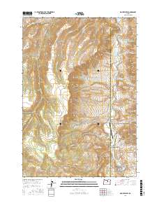
2017 Map of Mount Misery
USGS Topo · Published 2017About this map
Mount Misery and the surrounding high country of Wheeler County dominate this landscape, where deep canyons and ridges fall away toward the John Day River. The southeastern corner of the map features a significant portion of the John Day Fossil Beds National Monument, including the striking formation at Cathedral Rock and the drainage of Devils Gulch. This area is characterized by its complex topography and isolated ranching infrastructure, such as the Longview Ranch Airport located near the riverbank.
Find a feature on this map
38 named features on this map. Tap any name to fly to it.
Don’t see what you’re looking for? This feature index may not catch every label — zoom into the map to look around manually.
Map Details
Editions of this 2017 Mount Misery Map
This is the sole edition of this map. No revisions or reprints were ever made.
Other maps of this area

1953 · Richmond
USGS Topo · 1:62,500

1953 · Kimberly
USGS Topo · 1:62,500

1953 · Picture
USGS Topo · 1:62,500

1953 · Spray
USGS Topo · 1:62,500

1955 · Canyon City
USGS Topo · 1:250,000

1959 · Canyon City
USGS Topo · 1:250,000

1980 · Monument
USGS Topo · 1:100,000
1990 · Miller Flat
USGS Topo · 1:24,000
1990 · Tubb Spring
USGS Topo · 1:24,000
1990 · Picture Gorge West
USGS Topo · 1:24,000