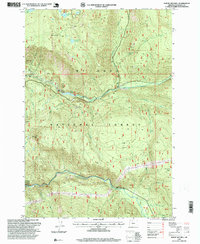
1997 Map of Mount Mitchell
USGS Topo · Published 1999About this map
Mt Hood National Forest encompasses this section of the Oregon Cascades during the late 1990s, defined by its steep terrain and industrial resource extraction. The Clackamas River carves through the landscape, flowing past Lake Harriet and through a series of dramatic elevation changes marked by Mount Mitchell and Oak Grove Butte. The map reveals an active timber and stone economy, evidenced by a dense network of forest roads leading to numerous excavation sites such as Thunder Quarry, Gae Zee Quarry, and Kli Quarry. Recreational and environmental features like Cottonwood Meadows and Hideaway Lake sit in contrast to the quarry operations, showing the dual-use nature of the national forest land at this time. A Gaging Sta on the river indicates the ongoing monitoring of this vital watershed.
Find a feature on this map
32 named features on this map. Tap any name to fly to it.
Don’t see what you’re looking for? This feature index may not catch every label — zoom into the map to look around manually.
Map Details
Editions of this 1997 Mount Mitchell Map
This is the sole edition of this map. No revisions or reprints were ever made.
Other maps of this area

1916 · Estacada
USGS Topo · 1:125,000

1924 · Mount Hood
USGS Topo · 1:125,000

1927 · Mount Hood
USGS Topo · 1:125,000

1927 · Mt. Jefferson
USGS Topo · 1:125,000

1929 · Mill City
USGS Topo · 1:125,000

1930 · Mt. Jefferson
USGS Topo · 1:125,000

1948 · Vancouver
USGS Topo · 1:250,000

1950 · Vancouver
USGS Topo · 1:250,000

1950 · Vancouver
USGS Topo · 1:250,000

1953 · Salem
USGS Topo · 1:250,000