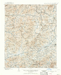
1900 Map of Mount Mitchell
USGS Topo · Published 1966About this map
The Blue Ridge divides the landscape of western North Carolina at the turn of the century, separating the headwaters of the Catawba River from the Cane River and South Fork Toe River systems. This survey, conducted by Glenn S. Smith and W.N. Brown, documents a period when the Southern Railway and its Asheville and Salisbury Line were the primary arteries for commerce, serving established settlements like Marion and Old Fort. The map illustrates the early development of Sprucepine and Burnsville before the widespread expansion of mountain roads. Named peaks and gaps like Lanes Pinnacle and Bald Creek Gap provide a detailed look at the topographic obstacles faced by early surveyors. Local heritage is preserved in the location of smaller communities such as Micaville, Pensacola, and Graphiteville, alongside the emerging boundaries of the Pisgah National Forest.
Find a feature on this map
300 named features on this map. Tap any name to fly to it.
Don’t see what you’re looking for? This feature index may not catch every label — zoom into the map to look around manually.
Map Details
Editions of this 1900 Mount Mitchell Map
3 editions found
Other maps of this area

1891 · Roan Mountain
USGS Topo · 1:125,000

1892 · Greeneville
USGS Topo · 1:125,000

1893 · Cranberry
USGS Topo · 1:125,000

1894 · Asheville
USGS Topo · 1:125,000

1894 · Roan Mountain
USGS Topo · 1:125,000

1895 · Cranberry
USGS Topo · 1:125,000

1896 · Greeneville
USGS Topo · 1:125,000

1899 · Cranberry
USGS Topo · 1:125,000

1900 · Mount Mitchell
USGS Topo · 1:125,000

1901 · Asheville
USGS Topo · 1:125,000