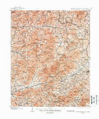
1900 Map of Mount Mitchell
USGS Topo · Published 1966About this map
Mount Mitchell serves as the focal point for this turn-of-the-century topographic study, which captures the high-altitude landscape of western North Carolina before the widespread expansion of motorized transport. The Southern Railway winds through the southern portion of the map, connecting growing hubs like Black Mountain and Swannanoa to the larger centers of Biltmore and Marion. The map reveals the intricate network of the Black Mountains and the Great Craggy Mountains, where early settlements like Pensacola and Barnardsville are situated along the Cane River and Ivy River headwaters. Local industry is marked by features like a Mica Mine near Micaville, while the presence of the Pisgah National Forest indicates the early conservation efforts in these highlands. The layout of small hamlets such as Graphiteville and Newdale reflects a mountain economy built around river valleys and rail access during this era of peak industrial transition.
Find a feature on this map
143 named features on this map. Tap any name to fly to it.
Don’t see what you’re looking for? This feature index may not catch every label — zoom into the map to look around manually.
Map Details
Editions of this 1900 Mount Mitchell Map
3 editions found
Other maps of this area

1891 · Roan Mountain
USGS Topo · 1:125,000

1892 · Greeneville
USGS Topo · 1:125,000

1893 · Cranberry
USGS Topo · 1:125,000

1894 · Asheville
USGS Topo · 1:125,000

1894 · Roan Mountain
USGS Topo · 1:125,000

1895 · Cranberry
USGS Topo · 1:125,000

1896 · Greeneville
USGS Topo · 1:125,000

1899 · Cranberry
USGS Topo · 1:125,000

1900 · Mount Mitchell
USGS Topo · 1:125,000

1901 · Asheville
USGS Topo · 1:125,000