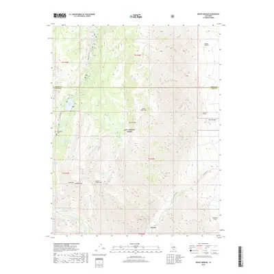
2018 Map of Mount Morgan
USGS Topo · Published 2018About this map
Inyo National Forest dominates this high-altitude terrain where the Sierra Nevada crest meets the border of Mono and Inyo Counties. The landscape is defined by the massive granite forms of Mt Morgan, Wheeler Ridge, and the sharp profile of Broken Finger Peak. This 2018 survey reveals a complex network of alpine hydrology, including Rock Creek Lake, Tamarack Lakes, and the twin basins of Upper Morgan Lake and Lower Morgan Lake. In the southeastern corner, the settlement of Scheelite serves as a lone human outpost at the base of the mountains, linked to the wider region by Pine Creek Rd. The map provides a detailed view of the high meadows and canyons, such as Ainslee Meadow and Mayfield Canyon, which have long drawn researchers and outdoorsmen to these elevations.
Find a feature on this map
36 named features on this map. Tap any name to fly to it.
Don’t see what you’re looking for? This feature index may not catch every label — zoom into the map to look around manually.
Map Details
Editions of this 2018 Mount Morgan Map
This is the sole edition of this map. No revisions or reprints were ever made.
Other maps of this area

1912 · Mt. Goddard
USGS Topo · 1:125,000

1914 · Mt. Morrison
USGS Topo · 1:125,000

1947 · Mariposa
USGS Topo · 1:250,000

1948 · Mariposa
USGS Topo · 1:250,000

1949 · Mt. Tom
USGS Topo · 1:62,500

1951 · Mt. Tom
USGS Topo · 1:62,500

1953 · Mt. Morrison
USGS Topo · 1:62,500

1953 · Casa Diablo Mtn
USGS Topo · 1:62,500

1953 · Mt Abbot
USGS Topo · 1:62,500
1954 · Mt. Tom
USGS Topo · 1:62,500