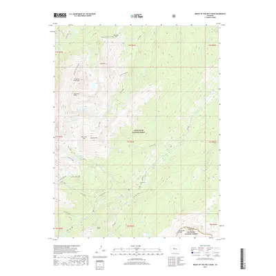
2019 Map of Mount of the Holy Cross
USGS Topo · Published 2019About this map
Mt of the Holy Cross anchors this high-elevation landscape, where the rugged topography of the White River National Forest meets the northern reaches of the San Isabel National Forest. The map captures a dramatic alpine environment defined by the Continental Divide and a series of glacial cirques containing remarkably named water bodies like the Bowl of Tears, Lake Constantine, and the Seven Sisters Lakes. Evidence of high-altitude human activity is present at the Missouri Tunnel and the isolated Gold Park Cem, located near the drainage of Homestake Cr. The density of named peaks and passes, including Whitney Peak and Half Moon Pass, illustrates the historical importance of these corridors for early mountaineers and surveyors. The drainage patterns of Cross Creek and Fall Creek create deeply incised valleys that have dictated the placement of local routes like the Fancy Lake Spur.
Find a feature on this map
55 named features on this map. Tap any name to fly to it.
Don’t see what you’re looking for? This feature index may not catch every label — zoom into the map to look around manually.
Map Details
Editions of this 2019 Mount of the Holy Cross Map
This is the sole edition of this map. No revisions or reprints were ever made.
Other maps of this area

1889 · Leadville
USGS Topo · 1:125,000

1891 · Leadville
USGS Topo · 1:125,000

1909 · Mount Jackson
USGS Topo · 1:125,000

1911 · Mount Jackson
USGS Topo · 1:125,000

1934 · Minturn
USGS Topo · 1:62,500

1942 · Leadville
USGS Topo · 1:125,000

1949 · Holy Cross
USGS Topo · 1:62,500

1950 · Minturn
USGS Topo · 1:62,500

1951 · Holy Cross
USGS Topo · 1:62,500

1957 · Leadville
USGS Topo · 1:250,000