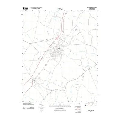
2010 Map of Mount Olive
USGS Topo · Published 2010About this map
Mount Olive and Calypso anchor this 2010 survey of Wayne County, showing the intersection of agricultural land and transportation corridors in eastern North Carolina. The landscape is defined by a dense network of watercourses, including the Northeast Cape Fear River and several low-lying drainage areas such as Thunder Swamp, Brooks Swamp, and Goshen Swamp. The map details the developed core of Mount Olive, featuring Carver Memorial Park and the Maplewood Cemetery, while also capturing the more rural outskirts where family-named landmarks like Price Cemetery and Wilson Cemetery are located.
Find a feature on this map
69 named features on this map. Tap any name to fly to it.
Don’t see what you’re looking for? This feature index may not catch every label — zoom into the map to look around manually.
Map Details
Editions of this 2010 Mount Olive Map
This is the sole edition of this map. No revisions or reprints were ever made.
Other maps of this area

1953 · Rocky Mount
USGS Topo · 1:250,000

1953 · Raleigh
USGS Topo · 1:250,000

1954 · Rocky Mount
USGS Topo · 1:250,000

1954 · Raleigh
USGS Topo · 1:250,000

1957 · Goldsboro
USGS Topo · 1:62,500

1957 · Seven Springs
USGS Topo · 1:62,500

1974 · Grantham
USGS Topo · 1:24,000

1974 · Southwest Goldsboro
USGS Topo · 1:24,000

1975 · Faison
USGS Topo · 1:24,000
1977 · Warsaw North
USGS Topo · 1:24,000