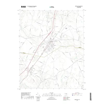
2019 Map of Mount Olive
USGS Topo · Published 2019About this map
Mount Olive serves as the central hub of this eastern North Carolina landscape, where the town's grid meets the agricultural reaches of both Wayne and Duplin counties. The terrain is defined by a complex drainage network, notably the Northeast Cape Fear River and the extensive Thunder Swamp and Brooks Swamp systems. This map captures the town in a modern context, featuring the Mount Olive Municipal Airport and Carver Memorial Park. For those tracing local heritage, the survey identifies several burial sites including Price Cem, Maplewood Cem, and Wilson Cem. Just to the southwest, the town of Calypso is clearly delineated along the rail corridor, providing a clear view of the relationship between these small railroad-aligned communities and the surrounding wetlands and fields that have long supported the regional economy.
Find a feature on this map
128 named features on this map. Tap any name to fly to it.
Don’t see what you’re looking for? This feature index may not catch every label — zoom into the map to look around manually.
Map Details
Editions of this 2019 Mount Olive Map
This is the sole edition of this map. No revisions or reprints were ever made.
Other maps of this area

1953 · Rocky Mount
USGS Topo · 1:250,000

1953 · Raleigh
USGS Topo · 1:250,000

1954 · Rocky Mount
USGS Topo · 1:250,000

1954 · Raleigh
USGS Topo · 1:250,000

1957 · Goldsboro
USGS Topo · 1:62,500

1957 · Seven Springs
USGS Topo · 1:62,500

1974 · Grantham
USGS Topo · 1:24,000

1974 · Southwest Goldsboro
USGS Topo · 1:24,000

1975 · Faison
USGS Topo · 1:24,000
1977 · Warsaw North
USGS Topo · 1:24,000