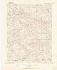
1905 Map of Mount Olympus
USGS Topo · Published 1962About this map
Rustic Hotel and a series of private homesteads anchor this early 20th-century landscape in the Colorado Front Range. Surveyed by Frank Tweedy in 1905, the map documents the transition from early ranching and mining to the burgeoning mountain tourism of the era. Concentrations of settlement like Loveland Heights and The Orchard are situated along the Big Thompson River, while the southern reaches show early family landholdings such as Plums Ranch and Miners Ranch near the Larimer and Boulder County line. The topographical detail, with a 100-foot contour interval, captures the prominence of Mt Olympus and Storm Mtn. The survey includes early park boundaries for Roosevelt National Forest and the edge of Rocky Mountain National Park, illustrating the region's preservation just as it became a destination for western travel.
Find a feature on this map
64 named features on this map. Tap any name to fly to it.
Don’t see what you’re looking for? This feature index may not catch every label — zoom into the map to look around manually.
Map Details
Editions of this 1905 Mount Olympus Map
2 editions found
Other maps of this area

1902 · Boulder
USGS Topo · 1:62,500

1904 · Niwot
USGS Topo · 1:62,500

1904 · Boulder
USGS Topo · 1:62,500

1905 · Mount Olympus
USGS Topo · 1:62,500

1906 · Loveland
USGS Topo · 1:62,500

1906 · Fort Collins
USGS Topo · 1:62,500

1907 · Mount Olympus
USGS Topo · 1:62,500

1907 · Livermore
USGS Topo · 1:125,000

1908 · Loveland
USGS Topo · 1:62,500

1908 · Fort Collins
USGS Topo · 1:62,500