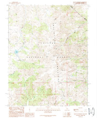
1989 Map of Mount Patterson
USGS Topo · Published 1989About this map
Sweetwater Mountains dominate this high-altitude survey of the Toiyabe National Forest at the close of the 1980s. This region is defined by its deep mining heritage, evidenced by numerous prospects and named operations such as the Angelo Mission Mine, Montague Mine, and the Tiger Mines cluster. The historical Von Schmidt Boundary slices across the northeastern corner, marking an early attempt to define the border between California and Nevada. Small human imprints appear at Nugent Cabin and the settlement of Belfort, positioned near the headwaters of Ferris Canyon. The landscape is characterized by steep drainages including Quaking Asp Canyon and Fryingpan Canyon, which fall away from the massive heights of Mount Patterson and Wheeler Peak. These features reflect a legacy of prospecting and grazing in the remote Eastern Sierra, where water sources like Lobdell Lake were vital for both industrial and agricultural pursuits.
Find a feature on this map
34 named features on this map. Tap any name to fly to it.
Don’t see what you’re looking for? This feature index may not catch every label — zoom into the map to look around manually.
Map Details
Editions of this 1989 Mount Patterson Map
2 editions found
Other maps of this area

1891 · Wellington
USGS Topo · 1:125,000

1893 · Wellington
USGS Topo · 1:125,000

1909 · Bridgeport
USGS Topo · 1:125,000

1911 · Bridgeport
USGS Topo · 1:125,000

1920 · Bridgeport
USGS Topo · 1:125,000

1948 · Walker Lake
USGS Topo · 1:250,000

1954 · Chris Flat
USGS Topo · 1:24,000

1954 · Fales Hot Springs
USGS Topo · 1:24,000

1956 · Desert Creek Peak
USGS Topo · 1:62,500

1956 · Fales Hot Springs
USGS Topo · 1:62,500