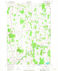
1948 Map of Mount Philo
USGS Topo · Published 1968About this map
The rolling Champlain Valley landscape of Chittenden County comes into sharp focus during the late 1940s, a period when the rural character of Vermont remained dominated by small hamlets and agricultural crossroads. Shelburne Falls and East Charlotte anchor the northern and central portions of the sheet, while the southern boundary follows the Chittenden Co Addison Co line through North Ferrisburg. Prominent topographic features like Mount Philo, topped with its Airway Beacon, and Pease Mountain rise sharply from the surrounding fields, offering a contrast to the meandering path of the La Platte River and Lewis Creek.
Find a feature on this map
34 named features on this map. Tap any name to fly to it.
Don’t see what you’re looking for? This feature index may not catch every label — zoom into the map to look around manually.
Map Details
Editions of this 1948 Mount Philo Map
4 editions found

Other maps of this area

1894 · Port Henry
USGS Topo · 1:62,500

1895 · Willsboro
USGS Topo · 1:62,500

1898 · Port Henry
USGS Topo · 1:62,500

1903 · Middlebury
USGS Topo · 1:62,500

1905 · Middlebury
USGS Topo · 1:62,500

1906 · Burlington
USGS Topo · 1:62,500

1919 · Burlington
USGS Topo · 1:62,500

1920 · Middlebury
USGS Topo · 1:62,500

1941 · Willsboro
USGS Topo · 1:62,500

1943 · Willsboro
USGS Topo · 1:62,500