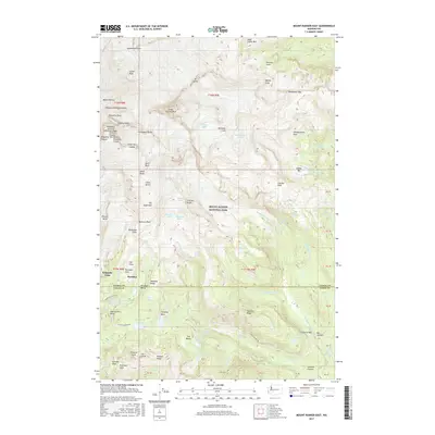
2017 Map of Mount Rainier East
USGS Topo · Published 2017About this map
Mount Rainier National Park dominates this terrain, centered on the high-altitude reaches of the mountain's eastern flanks and the popular visitor hub at Paradise. The landscape is defined by massive ice structures and rocky spurs, including the Nisqually Ice Cliff, Gibraltar Rock, and the prominent Little Tahoma Peak. In the lower elevations to the south, the park's developed infrastructure is visible along Stevens Canyon Rd and near the Reflection Lakes. This detailed survey reveals a complex network of glacial features like the Fryingpan Glacier and Ohanapecosh Glacier, which feed into high-mountain drainages such as the Muddy Fork Cowlitz River. For those tracing the geography of the park, the map identifies numerous specific landmarks used by climbers and hikers, from the high-elevation shelter at Camp Muir and the Saddle to secluded natural features like Indian Bar and Fan Lake.
Find a feature on this map
112 named features on this map. Tap any name to fly to it.
Don’t see what you’re looking for? This feature index may not catch every label — zoom into the map to look around manually.
Map Details
Editions of this 2017 Mount Rainier East Map
This is the sole edition of this map. No revisions or reprints were ever made.
Other maps of this area

1924 · Mt Rainier
USGS Topo · 1:96,000

1928 · Mt Rainier
USGS Topo · 1:125,000

1950 · Yakima
USGS Topo · 1:250,000

1958 · Yakima
USGS Topo · 1:250,000

1961 · Yakima
USGS Topo · 1:250,000

1962 · Randle
USGS Topo · 1:62,500

1962 · Packwood
USGS Topo · 1:62,500
1971 · Sunrise
USGS Topo · 1:24,000
1971 · White River Park
USGS Topo · 1:24,000
1971 · Mt Rainier West
USGS Topo · 1:24,000