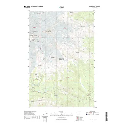
2020 Map of Mount Rainier East
USGS Topo · Published 2020About this map
Mount Rainier National Park dominates this high-altitude survey, centering on the glaciers and ridges of the mountain's eastern and southern flanks. The area around Paradise serves as a primary point of human activity, where the Paradise River flows near Paradise Park and Alta Vista. The map documents the extensive glacial systems that shape this landscape, including the massive Emmons Glacier, Nisqually Glacier, and the Ingraham Glacier. Significant natural landmarks such as Little Tahoma Peak and Gibraltar Rock are shown in high relief, providing a clear record of the vertical geography defined by Disappointment Cleaver and Cathedral Rocks.
Find a feature on this map
105 named features on this map. Tap any name to fly to it.
Don’t see what you’re looking for? This feature index may not catch every label — zoom into the map to look around manually.
Map Details
Editions of this 2020 Mount Rainier East Map
This is the sole edition of this map. No revisions or reprints were ever made.
Other maps of this area

1924 · Mt Rainier
USGS Topo · 1:96,000

1928 · Mt Rainier
USGS Topo · 1:125,000

1950 · Yakima
USGS Topo · 1:250,000

1958 · Yakima
USGS Topo · 1:250,000

1961 · Yakima
USGS Topo · 1:250,000

1962 · Randle
USGS Topo · 1:62,500

1962 · Packwood
USGS Topo · 1:62,500
1971 · Sunrise
USGS Topo · 1:24,000
1971 · White River Park
USGS Topo · 1:24,000
1971 · Mt Rainier West
USGS Topo · 1:24,000