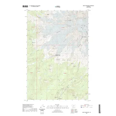
2020 Map of Mount Rainier West
USGS Topo · Published 2020About this map
Columbia Crest and the surrounding high-altitude glacial systems of Mount Rainier National Park dominate this survey. The landscape is defined by the massive radial drainage of the Tahoma Glacier, Nisqually Glacier, and Puyallup Glacier, which feed the headwaters of major waterways like the Nisqually River. Near the southern boundary, the settlement of Longmire serves as a primary point of human activity, situated near Longmire Meadow.
Find a feature on this map
105 named features on this map. Tap any name to fly to it.
Don’t see what you’re looking for? This feature index may not catch every label — zoom into the map to look around manually.
Map Details
Editions of this 2020 Mount Rainier West Map
This is the sole edition of this map. No revisions or reprints were ever made.
Other maps of this area

1924 · Mt Rainier
USGS Topo · 1:96,000

1928 · Mt Rainier
USGS Topo · 1:125,000

1950 · Yakima
USGS Topo · 1:250,000

1958 · Yakima
USGS Topo · 1:250,000

1961 · Yakima
USGS Topo · 1:250,000

1962 · Randle
USGS Topo · 1:62,500

1962 · Packwood
USGS Topo · 1:62,500
1971 · Sunrise
USGS Topo · 1:24,000
1971 · Mt Rainier West
USGS Topo · 1:24,000
1971 · Mount Wow
USGS Topo · 1:24,000