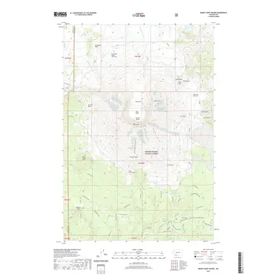
2020 Map of Mount Saint Helens
USGS Topo · Published 2020About this map
Mt Saint Helens stands as the central feature of this 2020 topographic study, documenting the complex recovery and geological shifts of the landscape decades after its major eruption. The detailed contours delineate the 1980 Crater and the emerging Lava Dome, providing a precise record of the current volcanic topography within the Gifford Pinchot National Forest. Glacial movement is still prominent, with the Toutle Glacier, Shoestring Glacier, and Dryer Glacier clinging to the slopes above the debris-filled drainage of the N Fork Toutle River. Surrounding the peak, the map traces modern recreational and research access, from the Climber's Bivouac and Monitor Ridge Climbing Route to the extensive trail network including the Loowit and Abraham trails that cross the Plains of Abraham. This recent survey serves as a vital record for geologists and hikers tracking the evolving terrain of the Swift Creek Flow and the volatile Lava Canyon.
Find a feature on this map
69 named features on this map. Tap any name to fly to it.
Don’t see what you’re looking for? This feature index may not catch every label — zoom into the map to look around manually.
Map Details
Editions of this 2020 Mount Saint Helens Map
This is the sole edition of this map. No revisions or reprints were ever made.
Other maps of this area

1919 · Mount St Helens
USGS Topo · 1:125,000

1953 · Hoquiam
USGS Topo · 1:250,000
1953 · Cougar
USGS Topo · 1:62,500
1953 · Elk Rock
USGS Topo · 1:62,500
1957 · Hoquiam
USGS Topo · 1:250,000
1957 · Spirit Lake
USGS Topo · 1:62,500
1958 · Mt St. Helens
USGS Topo · 1:62,500
1958 · Hoquiam
USGS Topo · 1:250,000
1962 · Hoquiam
USGS Topo · 1:250,000

1975 · Mt. St. Helens NE
USGS Topo · 1:24,000