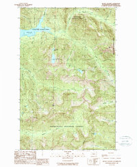
1989 Map of Mount Stickney
USGS Topo · Published 1989About this map
Kromona Mine and several Quarries indicate the industrial extraction occurring within the high-elevation terrain of Snoqualmie National Forest during the late 1980s. The landscape is defined by its complex drainage systems, including the Sultan River and its multiple branches, which feed into the large reservoir of Spada Lake. The map reveals a network of alpine water bodies such as Big Greider Lake, Little Greider Lake, and Boulder Lake, which characterize the glacial geography of the Cascade Range. Notable summits like Mt Stickney, Prospect Peak, and Red Mtn rise above Ragger Ridge, illustrating the steep vertical relief of the Snohomish County backcountry. The presence of a Campground near Boulder Creek reflects the area's transition toward recreational utility alongside established mining interests.
Find a feature on this map
38 named features on this map. Tap any name to fly to it.
Don’t see what you’re looking for? This feature index may not catch every label — zoom into the map to look around manually.
Map Details
Editions of this 1989 Mount Stickney Map
This is the sole edition of this map. No revisions or reprints were ever made.
Other maps of this area

1899 · Glacier Peak
USGS Topo · 1:125,000

1899 · Stillaguamish
USGS Topo · 1:125,000

1901 · Glacier Peak
USGS Topo · 1:125,000

1901 · Stilaguamish
USGS Topo · 1:125,000

1902 · Skykomish
USGS Topo · 1:125,000

1905 · Skykomish
USGS Topo · 1:125,000

1921 · Sultan
USGS Topo · 1:125,000

1923 · Sultan
USGS Topo · 1:125,000

1955 · Concrete
USGS Topo · 1:250,000

1957 · Silverton
USGS Topo · 1:62,500