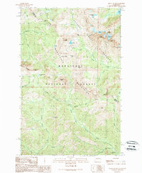
1989 Map of Mount Stuart
USGS Topo · Published 1989About this map
Mount Stuart dominates this late-twentieth-century landscape, serving as the high point of the Stuart Range within the Alpine Lakes Wilderness. The survey, revised from 1980s aerial photography, documents a complex network of high-altitude glaciers including the Stuart Glacier, Ice Cliff Glacier, and Sherpa Glacier. This area, split by the Chelan County and Kittitas County line, is defined by its drainage systems, where the North Fork Teanaway River and Middle Fork Teanaway River begin their descent through the Wenatchee National Forest.
Find a feature on this map
46 named features on this map. Tap any name to fly to it.
Don’t see what you’re looking for? This feature index may not catch every label — zoom into the map to look around manually.
Map Details
Editions of this 1989 Mount Stuart Map
2 editions found
Other maps of this area

1897 · Mount Stuart
USGS Topo · 1:125,000

1901 · Chiwaukum
USGS Topo · 1:125,000

1901 · Snoqualmie Pass
USGS Topo · 1:125,000

1902 · Skykomish
USGS Topo · 1:125,000

1902 · Mount Stuart
USGS Topo · 1:125,000

1903 · Snoqualmie
USGS Topo · 1:125,000

1904 · Chiwaukum
USGS Topo · 1:125,000

1905 · Skykomish
USGS Topo · 1:125,000

1957 · Wenatchee
USGS Topo · 1:250,000

1961 · Mount Stuart
USGS Topo · 1:62,500