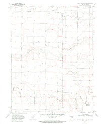
1969 Map of Mount Sunflower NE
USGS Topo · Published 1972About this map
The high plains of the Colorado-Kansas state line are defined by a network of drainage basins and isolated educational outposts in the late 1960s. The landscape is carved by several eastward-flowing watercourses, most notably the North Fork Smoky Hill River and the upper reaches of Sappa Creek. Between these drainage systems, the open terrain of McPherson and Morton is punctuated by the Green Valley Sch, a critical node for the rural community in this portion of Kit Carson and Sherman Counties.
Find a feature on this map
13 named features on this map. Tap any name to fly to it.
Don’t see what you’re looking for? This feature index may not catch every label — zoom into the map to look around manually.
Map Details
Editions of this 1969 Mount Sunflower NE Map
This is the sole edition of this map. No revisions or reprints were ever made.
Other maps of this area

1954 · Limon
USGS Topo · 1:250,000

1954 · Goodland
USGS Topo · 1:250,000

1956 · Goodland
USGS Topo · 1:250,000

1957 · Limon
USGS Topo · 1:250,000

1957 · Goodland
USGS Topo · 1:250,000

1958 · Limon
USGS Topo · 1:250,000

1959 · Horsethief Draw
USGS Topo · 1:62,500

1966 · Ruleton
USGS Topo · 1:24,000

1969 · Mount Sunflower SW
USGS Topo · 1:24,000
1969 · Mount Sunflower
USGS Topo · 1:24,000