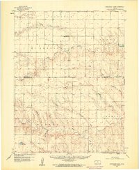
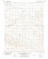
1959 Map of Horsethief Draw
USGS Topo · Published 1960About this map
The Smoky Hill River and its various tributaries define this Western Kansas landscape, where the high plains are carved by an intricate network of draws and creeks. This late 1950s survey documents a rural environment centered on the convergence of the North Fork Smoky Hill River and other drainage systems like Horsethief Draw and Armstrong Draw. These seasonal watercourses dictate the placement of human activity, such as the Gravel Pit near the river’s north fork.
Find a feature on this map
26 named features on this map. Tap any name to fly to it.
Don’t see what you’re looking for? This feature index may not catch every label — zoom into the map to look around manually.
Map Details
Editions of this 1959 Horsethief Draw Map
2 editions found
Other maps of this area

1892 · Cheyenne Wells
USGS Topo · 1:125,000
1894 · Cheyenne Wells
USGS Topo · 1:125,000

1954 · Limon
USGS Topo · 1:250,000

1954 · Lamar
USGS Topo · 1:250,000

1954 · Goodland
USGS Topo · 1:250,000

1955 · Scott City
USGS Topo · 1:250,000

1956 · Goodland
USGS Topo · 1:250,000

1957 · Limon
USGS Topo · 1:250,000

1957 · Goodland
USGS Topo · 1:250,000

1958 · Limon
USGS Topo · 1:250,000