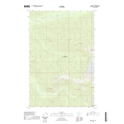
2020 Map of Mount Tom
USGS Topo · Published 2020About this map
Olympic National Park defines this landscape in the western reaches of Jefferson County, dominated by the massive relief of the Olympic Mountains. The terrain is centered on high summits including Mt Tom and the nearby Hoh Peak, which serve as the headwaters for several significant drainages. The Hoh River flows across the northern section, accompanied by the Hoh River Trail, a critical route for back-country access. To the south, the South Fork Hoh River cuts through the topography, joined by smaller tributaries like Cougar Cr and Lake Cr. High-elevation water bodies like Dragon Lake are captured here, illustrating the drainage patterns that feed into the larger river systems. This area represents a preserved wilderness environment where glacial and fluvial processes continue to shape the land.
Find a feature on this map
17 named features on this map. Tap any name to fly to it.
Don’t see what you’re looking for? This feature index may not catch every label — zoom into the map to look around manually.
Map Details
Editions of this 2020 Mount Tom Map
This is the sole edition of this map. No revisions or reprints were ever made.
Other maps of this area

1935 · Mount Olympus
USGS Topo · 1:62,500

1939 · Mount Tom
USGS Topo · 1:62,500

1942 · Mount Olympus
USGS Topo · 1:62,500

1947 · Mt Christie
USGS Topo · 1:62,500

1950 · Mt Christie
USGS Topo · 1:62,500

1950 · Slide Peak
USGS Topo · 1:24,000
1950 · Bogachiel Peak
USGS Topo · 1:24,000
1950 · Mount Carrie
USGS Topo · 1:24,000

1956 · Mount Olympus
USGS Topo · 1:62,500

1956 · Kloochman Rock
USGS Topo · 1:62,500