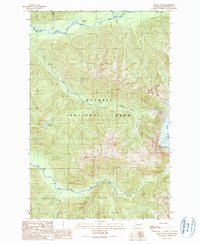
1990 Map of Mount Tom
USGS Topo · Published 1990About this map
Olympic National Park defines the vast glacial and riverine landscape of this 1990 provisional study. The terrain is dominated by the massive White Glacier which feeds the headwaters of regional drainages, including the Hoh River to the north and the South Fork Hoh River to the south. Prominent summits like Mount Tom and Hoh Peak overlook a network of steep-cut valleys and high-elevation water bodies such as Dragon Lake.
Find a feature on this map
14 named features on this map. Tap any name to fly to it.
Don’t see what you’re looking for? This feature index may not catch every label — zoom into the map to look around manually.
Map Details
Editions of this 1990 Mount Tom Map
This is the sole edition of this map. No revisions or reprints were ever made.
Other maps of this area

1935 · Mount Olympus
USGS Topo · 1:62,500

1939 · Mount Tom
USGS Topo · 1:62,500

1942 · Mount Olympus
USGS Topo · 1:62,500

1947 · Mt Christie
USGS Topo · 1:62,500

1950 · Mt Christie
USGS Topo · 1:62,500

1950 · Slide Peak
USGS Topo · 1:24,000
1950 · Bogachiel Peak
USGS Topo · 1:24,000
1950 · Mount Carrie
USGS Topo · 1:24,000

1956 · Mount Olympus
USGS Topo · 1:62,500

1956 · Kloochman Rock
USGS Topo · 1:62,500