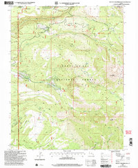
2001 Map of Mount Tukuhnikivatz
USGS Topo · Published 2004About this map
Mount Tukuhnikivatz and South Mountain dominate this landscape within the Manti-La Sal National Forest, where the high peaks of the La Sal Mountains meet deep drainage systems. The survey reveals a complex network of canyons and mesas, including South Mesa and Brumley Ridge, carved by water bodies such as Mill Creek and Brumley Creek. Historical mining activity is marked at the Yellow Circle Mines near the southern boundary, while recreational use is evident at the Geyser Pass Winter Sports area.
Find a feature on this map
37 named features on this map. Tap any name to fly to it.
Don’t see what you’re looking for? This feature index may not catch every label — zoom into the map to look around manually.
Map Details
Editions of this 2001 Mount Tukuhnikivatz Map
This is the sole edition of this map. No revisions or reprints were ever made.
Other maps of this area

1885 · La Sal
USGS Topo · 1:250,000

1954 · Mt. Waas 4 SW
USGS Topo · 1:24,000

1954 · Mt Peale 1 SW
USGS Topo · 1:24,000

1954 · Mt Peale 1 NW
USGS Topo · 1:24,000

1954 · Mt Peale 2 SW
USGS Topo · 1:24,000

1954 · Mt Peale 2 NW
USGS Topo · 1:24,000

1954 · Mt Peale 2 SE
USGS Topo · 1:24,000

1954 · Mt. Waas 3 SE
USGS Topo · 1:24,000

1954 · Mt Peale 2 NE
USGS Topo · 1:24,000

1954 · Mt. Waas 3 SW
USGS Topo · 1:24,000