
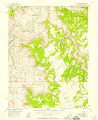
1954 Map of Mt. Waas 3 SW
USGS Topo · Published 1956About this map
Wilson Mesa and South Mesa dominate the eastern landscape of this 1954 survey, rising above the intricate drainage networks of the canyon country. To the west, the outskirts of a growing community are marked by Moab City Park, while the surrounding terrain is defined by deep cuts such as Negro Bill Canyon and Jackass Canyon. This preliminary edition captures the area's transition into the mid-century, showing a Landing Strip perched on the high ground of the mesa, indicating the increasing importance of aerial access in this isolated environment.
Find a feature on this map
19 named features on this map. Tap any name to fly to it.
Don’t see what you’re looking for? This feature index may not catch every label — zoom into the map to look around manually.
Map Details
Editions of this 1954 Mt. Waas 3 SW Map
This is the sole edition of this map. No revisions or reprints were ever made.
Other maps of this area

1885 · La Sal
USGS Topo · 1:250,000

1954 · Mt Peale 2 NW
USGS Topo · 1:24,000

1954 · Mt. Waas 3 NE
USGS Topo · 1:24,000

1954 · Mt. Waas 3 SE
USGS Topo · 1:24,000

1954 · Carlisle 1 NE
USGS Topo · 1:24,000

1954 · Mt Peale 2 NE
USGS Topo · 1:24,000

1954 · Mt. Waas 3 NW
USGS Topo · 1:24,000

1954 · La Sal Junction
USGS Topo · 1:62,500

1954 · Castle Valley
USGS Topo · 1:62,500
1954 · Hatch Point
USGS Topo · 1:62,500