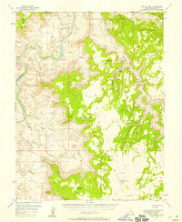
1954 Map of Hatch Point
USGS Topo · Published 1958About this map
Colorado River carved the deep canyons and plateaus seen in this mid-1950s survey of the high desert. The landscape is defined by massive formations like Hatch Point and Flat Iron Mesa, where survey markers such as VABM Horsehead 6491 Rock indicate the extreme verticality of the terrain. The presence of Oil Wells and an Oil Tank in Shafer Basin alongside scattered Prospects suggests the early post-war search for resources in this isolated corner of the state.
Find a feature on this map
38 named features on this map. Tap any name to fly to it.
Don’t see what you’re looking for? This feature index may not catch every label — zoom into the map to look around manually.
Map Details
Editions of this 1954 Hatch Point Map
3 editions found
Other maps of this area

1885 · La Sal
USGS Topo · 1:250,000

1951 · The Knoll
USGS Topo · 1:62,500

1951 · Upheaval Dome
USGS Topo · 1:62,500

1952 · Carlisle 2 SE
USGS Topo · 1:24,000

1952 · Moab 3 SE
USGS Topo · 1:24,000

1952 · Carlisle 2 NE
USGS Topo · 1:24,000

1952 · Moab 4 SW
USGS Topo · 1:24,000

1953 · The Needles
USGS Topo · 1:62,500

1954 · Mt Peale 3 NW
USGS Topo · 1:24,000

1954 · Mt Peale 2 SW
USGS Topo · 1:24,000