
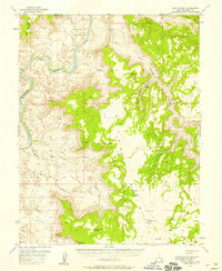
1952 Map of Moab 4 SW
USGS Topo · Published 1954About this map
The Colorado River carves a deep path through this 1952 preliminary survey, defining the rugged geography where Grand and San Juan Counties meet. The map documents a landscape of immense vertical relief, featuring named landmarks like the Jug Handle and the Billboard rising above the river's eastern banks. While much of the terrain is defined by sprawling plateaus like Big Flat and Arts Pasture, early industrial activity is visible via a pipe line and isolated structures such as an oil well and oil tank located near Jackson Hole.
Find a feature on this map
22 named features on this map. Tap any name to fly to it.
Don’t see what you’re looking for? This feature index may not catch every label — zoom into the map to look around manually.
Map Details
Editions of this 1952 Moab 4 SW Map
This is the sole edition of this map. No revisions or reprints were ever made.
Other maps of this area

1885 · La Sal
USGS Topo · 1:250,000

1951 · The Knoll
USGS Topo · 1:62,500

1951 · Upheaval Dome
USGS Topo · 1:62,500

1952 · Moab 4 NW
USGS Topo · 1:24,000

1952 · Moab 3 NE
USGS Topo · 1:24,000

1952 · Moab 3 SE
USGS Topo · 1:24,000

1952 · Carlisle 2 NE
USGS Topo · 1:24,000

1954 · Carlisle 1 NE
USGS Topo · 1:24,000

1954 · Carlisle 1 NW
USGS Topo · 1:24,000
1954 · Hatch Point
USGS Topo · 1:62,500