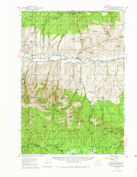
1940 Map of Mount Vernon
USGS Topo · Published 1982About this map
Mount Vernon serves as the central hub of this Grant County landscape, situated where the John Day River flows through the valley. The map documents a rural economy transitioning from early resource extraction to established ranching, evidenced by family holdings such as the Fletcher Ranch and Koehler Ranch. While mining activity is noted at the Cinnabar Mine and the abandoned Silvers Mine, the presence of the Belshaw Sch and Luce Sch indicates a community settled enough to support local education districts.
Find a feature on this map
71 named features on this map. Tap any name to fly to it.
Don’t see what you’re looking for? This feature index may not catch every label — zoom into the map to look around manually.
Map Details
Editions of this 1940 Mount Vernon Map
2 editions found
Other maps of this area

1940 · Mount Vernon
USGS Topo · 1:62,500

1940 · Aldrich Mtn.
USGS Topo · 1:62,500

1940 · John Day
USGS Topo · 1:62,500

1943 · Aldrich Mtn.
USGS Topo · 1:62,500

1943 · John Day
USGS Topo · 1:62,500

1943 · Mount Vernon
USGS Topo · 1:62,500

1949 · Long Creek
USGS Topo · 1:62,500

1949 · Susanville
USGS Topo · 1:62,500

1951 · Susanville
USGS Topo · 1:62,500

1951 · Long Creek
USGS Topo · 1:62,500