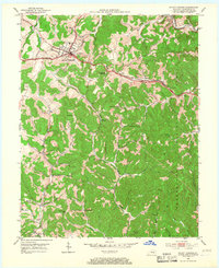
1953 Map of Mount Vernon
USGS Topo · Published 1967About this map
The town of Mount Vernon serves as a central hub in this mid-century portrait of Rockcastle County, where the historic Wilderness Road and the Louisville and Nashville railroad intersect. The map reveals a deeply etched landscape of ridges and hollows, where small settlements like Burr and Pine Hill are anchored by local institutions such as the Pine Hill Sch and Lover Cem. To the south and east, the terrain transitions into the protected slopes of the Cumberland National Forest, while the northern area near Orlando (Brush Creek Sta) follows the winding course of Roundstone Creek. This document preserves a dense network of rural infrastructure, including numerous family and community schools like Sowder Sch and Wellhope Sch, alongside the Shady Grove Ch, reflecting the distributed nature of mountain communities before modern school consolidation.
Find a feature on this map
42 named features on this map. Tap any name to fly to it.
Don’t see what you’re looking for? This feature index may not catch every label — zoom into the map to look around manually.
Map Details
Editions of this 1953 Mount Vernon Map
2 editions found

Other maps of this area

1893 · London
USGS Topo · 1:125,000

1897 · London
USGS Topo · 1:125,000

1952 · Billows
USGS Topo · 1:24,000

1952 · Shopville
USGS Topo · 1:24,000

1952 · Bernstadt
USGS Topo · 1:24,000

1953 · Johnetta
USGS Topo · 1:24,000

1953 · Maretburg
USGS Topo · 1:24,000

1953 · Wildie
USGS Topo · 1:24,000

1953 · Livingston
USGS Topo · 1:24,000
1953 · Brodhead
USGS Topo · 1:24,000