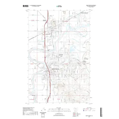
2020 Map of Mount Vernon
USGS Topo · Published 2020About this map
Mount Vernon and Burlington serve as the primary hubs of Skagit County, separated by the winding course of the Skagit River. This 2020 survey details the complex interface between urban infrastructure and the river’s floodplain, reaching from Chuckanut Junction in the north down to Skagit City and Fir Island near the river's split. The landscape is defined by its dramatic relief, notably the prominent Burlington Hill and Little Mtn, which rise abruptly from the valley floor. For local historians and genealogists, the map identifies key institutional landmarks including the Skagit County Courthouse, the Mount Vernon Cem, and the sprawling Skagit Valley College campus. The eastern edge of the quadrangle transitions into the foothills near Baker Heights, where the Nookachamps Creek drainage meets the East Fork Nookachamps Creek, illustrating the hydraulic complexity of this agricultural and timber-rich region.
Find a feature on this map
104 named features on this map. Tap any name to fly to it.
Don’t see what you’re looking for? This feature index may not catch every label — zoom into the map to look around manually.
Map Details
Editions of this 2020 Mount Vernon Map
This is the sole edition of this map. No revisions or reprints were ever made.
Other maps of this area

1911 · Mount Vernon
USGS Topo · 1:125,000

1918 · Samish Lake
USGS Topo · 1:62,500

1921 · Wickersham
USGS Topo · 1:62,500

1940 · Mt Vernon
USGS Topo · 1:62,500

1943 · Mt Vernon
USGS Topo · 1:62,500

1944 · Clear Lake
USGS Topo · 1:62,500

1951 · Wickersham
USGS Topo · 1:62,500

1952 · Alger
USGS Topo · 1:24,000

1954 · Bow
USGS Topo · 1:24,000

1954 · Samish Lake
USGS Topo · 1:62,500