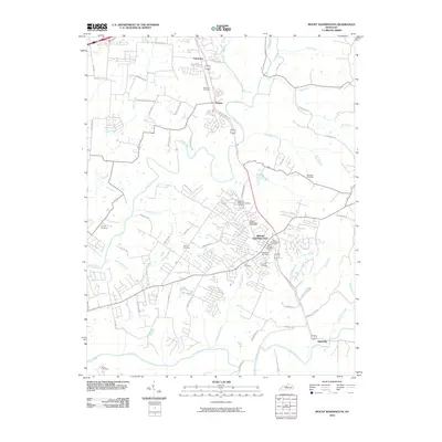
2010 Map of Mount Washington
USGS Topo · Published 2010About this map
Mount Washington serves as the central hub of this 2010 survey, showing the transition from suburban density to rural hillsides south of Louisville. The town is anchored by several long-standing local landmarks, including the Mount Washington Post Office and a dense cluster of historic burial grounds like Saint Francis Cemetery and Showalter Cemetery. To the north and south, smaller settlements like Fairmount and Smithville mark the perimeter of a landscape shaped by significant waterways. The Salt River flows across the southern reaches of the map, while the meandering Floyds Fork and its many tributaries, such as Bethel Branch, Whitaker Run, and Old Mans Run, define the local topography. This detailed layout provides a clear view of the roadway network, showing how routes like N Bardstown Rd and Bardstown Bluff connect these communities through the undulating terrain of Jefferson and Bullitt counties.
Find a feature on this map
67 named features on this map. Tap any name to fly to it.
Don’t see what you’re looking for? This feature index may not catch every label — zoom into the map to look around manually.
Map Details
Editions of this 2010 Mount Washington Map
This is the sole edition of this map. No revisions or reprints were ever made.
Other maps of this area

1907 · Louisville
USGS Topo · 1:62,500

1929 · Taylorsville
USGS Topo · 1:62,500

1949 · Shepherdsville
USGS Topo · 1:24,000

1949 · Samuels
USGS Topo · 1:24,000

1949 · Shepherdsville
USGS Topo · 1:62,500
1951 · Louisville East
USGS Topo · 1:24,000

1951 · Jeffersontown
USGS Topo · 1:24,000

1951 · Fisherville
USGS Topo · 1:24,000

1951 · Waterford
USGS Topo · 1:24,000
1951 · Brooks
USGS Topo · 1:24,000