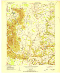
1951 Map of Brooks
USGS Topo · Published 1951About this map
The South Park Hills and a series of prominent knobs define this landscape along the border of Jefferson and Bullitt counties at the midpoint of the twentieth century. The Old National Turnpike and the Louisville and Nashville railroad provide the primary north-south transit corridor, linking settlements like South Park, Coral Ridge, and Brooks. The map reveals a deeply rooted rural community evidenced by numerous family cemeteries and local institutions, including the Julius Rosenwald Sch and several country churches like Little Flock Ch. To the south, the terrain descends toward the winding path of Floyds Fork and the Salt River, while high points like Buttonmold Knob and Wagonbed Knob overlook the developing valley. Notable infrastructure of the era is captured through the Airway Beacon and Holsclaw Lookout Tower, reflecting contemporary navigation and fire safety systems.
Find a feature on this map
52 named features on this map. Tap any name to fly to it.
Don’t see what you’re looking for? This feature index may not catch every label — zoom into the map to look around manually.
Map Details
Editions of this 1951 Brooks Map
This is the sole edition of this map. No revisions or reprints were ever made.
Other maps of this area

1907 · Louisville
USGS Topo · 1:62,500

1909 · Kosmosdale
USGS Topo · 1:48,000

1912 · Kosmosdale
USGS Topo · 1:62,500

1936 · Vine Grove
USGS Topo · 1:62,500

1943 · Vine Grove
USGS Topo · 1:62,500

1946 · Pitts Point
USGS Topo · 1:24,000

1946 · Vine Grove
USGS Topo · 1:62,500

1949 · Shepherdsville
USGS Topo · 1:24,000

1949 · Samuels
USGS Topo · 1:24,000

1949 · Shepherdsville
USGS Topo · 1:62,500