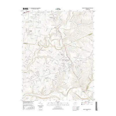
2016 Map of Mount Washington
USGS Topo · Published 2016About this map
Mount Washington serves as the central hub of this northern Kentucky survey, situated where the Jefferson, Bullitt, and Spencer county lines converge. The landscape is defined by the winding course of Floyds Fork and its numerous tributaries, including Broad Run and Old Mans Run, which carve through the undulating terrain. This 2016 edition documents the suburban expansion around Heritage Creek and Fairmount, contrasting established residential grids with the more open drainage basins of the Salt River near Smithville. Genealogists will find a wealth of local history preserved in the numerous family and community burial grounds scattered across the quadrangle, such as Markwell Cem, Gentry Cem, and Saint Francis Cem. The presence of landmarks like Bethel Ch and the curiously named Hell provide specific points of interest for those tracing the cultural and physical development of the region east of Louisville.
Find a feature on this map
195 named features on this map. Tap any name to fly to it.
Don’t see what you’re looking for? This feature index may not catch every label — zoom into the map to look around manually.
Map Details
Editions of this 2016 Mount Washington Map
This is the sole edition of this map. No revisions or reprints were ever made.
Other maps of this area

1907 · Louisville
USGS Topo · 1:62,500

1929 · Taylorsville
USGS Topo · 1:62,500

1949 · Shepherdsville
USGS Topo · 1:24,000

1949 · Samuels
USGS Topo · 1:24,000

1949 · Shepherdsville
USGS Topo · 1:62,500
1951 · Louisville East
USGS Topo · 1:24,000

1951 · Jeffersontown
USGS Topo · 1:24,000

1951 · Fisherville
USGS Topo · 1:24,000

1951 · Waterford
USGS Topo · 1:24,000
1951 · Brooks
USGS Topo · 1:24,000